Cadillac Mountain - Overlooking Bay
There is a Summit Path that encircles the main viewing area on the eastern side of the mountaintop next to the main and largest parking lot. This path is mostly made of granite as is most of the mountain itself. Although, the images presented here show mostly calm and peaceful situations, it sometimes is much different. There can be high winds, and temperatures can be cold. Be sure to bring at least a sweater and/or a jacket just in case. At times the whole mountain is enshrouded in a thick fog making travel a true challenge. It can also be damp.
The image above was captured on the eastern side of the Summit Path. When walking in this area, be very careful to only walk on the exposed granite. Plants do not have much to hold onto and can easily be damaged. Some areas will be blocked off from walking traffic in order to protect the vegetation. Please abide by the rules. Keep in mind that there are many wild blueberry plants here. If you are lucky, you may discover some and have a chance to pick and taste some blueberries right of the plant while ripe! These memories will stay with a child all the way through adulthood.
How to get there
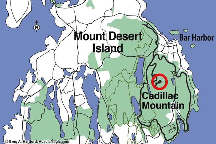
This map shows a section of Mount Desert Island with Bar Harbor at the upper right. Cadillac Mountain is directly to the south. There are two ways to get there by automobile. Both are via the Park Loop Road. Routes 233 and 3 intersect and provide entrance to the Park Loop Road on the northern side in Bar Harbor. There is also a entrance point on the southern side of the mountain in Seal Harbor which also goes by the Jordan Pond House and Bubble Pond before arriving at the beginning of the Summit Road. For those rugged individuals with lots of stamina, there are also some hiking trails that will take you there and back. Be sure to check the weather out before starting the journey.
Summit Road GPS: Latitude 44.368891; Longitude -68.238506
Use Caution while Driving
 The Summit Road winds for about two miles up the mountainous slope. Curves can be sharp and the roads can be damp. Even though you may be on the correct side of the road, on occasion, you may suddenly meet someone who is in a rush or not paying attention. Be on guard. There are a few pull-off points along the way. These can quickly fill up. It is rare to find someone walking the distance as they usually are doing this via the hiking trails but it is common to come upon someone biking.