Eagle Lake in Acadia

Eagle Lake, at 436 acres, is the largest fresh water lake in Acadia National Park on Mount Desert Island. It has a maximum depth of 110 feet and an average depth of 50 feet. Fishing is allowed but a license is required for Maine residents 16 years or older, and for nonresidents 12 years or older. You may gain access to the lake in Bar Harbor on the northern end off Route 233. There are two parking areas on either side of the road.

Eagle Lake Boat Landing GPS: Latitude 44.376513; Longitude -68.250634

Carriage Road at Eagle Lake
Eagle Lake
Eagle lake in Acadia National Park, Bar Harbor, Maine

Carriage Road

If inclined, you may walk or ride your bike completely around Eagle Lake on a 6.1 mile section of a Carriage Road which can be accessed from either parking area. You may also explore the lake from your own kayak or canoe. Kayak & Canoe Rentals as well as bike rentals are available at various locations on the island if needed. (Refer to the Activities or Shops links at the top of this page.) The free Island Explorer Shuttle Bus provides a seasonal pickup and drop-off point for those wanting to leave the driving to someone else. This is a good option for many visitors. Contact the service directly with specific questions about their schedules and about what you may take with you.

The Parking Area

From the parking area closest to the lake, you will notice a couple of short walking paths to the right that take you further out on a small point of land with some excellent views. This whole area has a variety of places to explore that will reward with some nice photographic opportunities.

The main connecting arteries through the woodlands and near the lakes are the Carriage Roads. You will see one going right by the north side of the lake, on the south side of Route 233. The Carriage Road on the western side extends to the North right under an arched stone bridge where there is access to the other parking area on the north side of Route 233.

Spectacular View

One of the most striking views of Eagle Lake is from the western observation area of Cadillac Mountain, especially near, during, and immediately after, a sunset. The skylight reflects on the surface of the water creating a gorgeous glow of color in a sea of the darker evergreen trees far below. This also offers a great perspective to see the size of the lake compared to other surrounding land features. For a short period of time, between 1883 and 1890, there were a couple of steam locomotives that made the climb from Eagle Lake to the summit of Cadillac Mountain and back. Visit the Cadillac Mountain page for more about this interesting story about Acadia's past.

Autumn sunbursts through the trees at Eagle Lake

Photo Suggestions

The lens, aperture, and shutter of a camera work in the same way as the human eye. When there's too much light for a correct exposure, the camera's aperture constricts. In our eyes, the iris gets smaller. Conversely, when it is too dark, both the camera aperture and the iris must expand to let more light in.

When photographing a strong back-lit scene, the camera's light meter may close the aperture, or reduce the shutter speed too much, resulting in an image that is too dark. To correct this, try changing your perspective slightly so that the sun is directly behind a tree branch. This technique can help maintain pleasing contrast while preserving the ambient colors of the entire scene. You can see this effect in the photo of the autumn leaves captured from Carriage Road at Eagle Lake.

How to Get Here

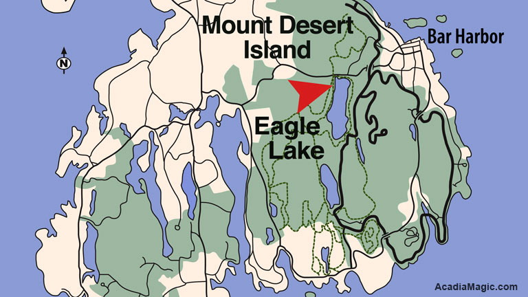
Refer to the map, and you'll see that Eagle Lake is positioned near the center of the largest green area of the park, situated on the southwestern side of Bar Harbor's business district. Route 233 runs directly west from this location along the northern shore of Eagle Lake. This route is particularly advantageous as it offers year-round access to the lake and the Carriage Roads that intersect and encircle it.

Additionally, Route 233 provides an access point to the Park Loop Road before reaching Eagle Lake. This access point, located on the right just before a stone-faced overpass, allows you to reach the Hulls Cove Visitor Center, Jordan Pond, Cadillac Mountain, or the main Park Loop Entrance Station, north of Sand Beach. Continuing on Route 233 past Eagle Lake will bring you to the northern end of Somes Sound, where it intersects with Routes 198 and 3. From here, a right turn leads to Somesville, while a left (south) leads towards Northeast Harbor.

Eagle Lake Location Map

Interesting Stats & Facts

  • Accessibility: Carriage Road, shoreline, restrooms and parking area.
  • Eagle Lake Fish: Landlocked salmon, brook trout, lake trout
  • Restrictions: Motors over 10 horsepower prohibited
  • Maine Department of Inland Fisheries: (207) 434-5925
    Wildlife Division: (207) 434-5927
  • Fishing Information
  • During late 1800's, a cog railway went from Eagle Lake to Cadillac Mountain Summit and back!
  • Eagle Lake Boat Landing: Latitude 44.376513; Longitude -68.250634
  • Visitor Center: Latitude 44.409286; Longitude -68.247501
  • Sand Beach Entrance Station: Latitude 44.338797; Longitude -68.183168
  • Cadillac Mountain: Latitude 44.368891; Longitude -68.238506
  • Park Entrance Station: Latitude 44.338797; Longitude -68.183168
  • Bass Harbor Lighthouse: Latitude 44.221991; Longitude -68.337198

Find Your Way Around

Greg A. Hartford, photographer, author, publisherThis is one of those park locations where a lot more is happening than initially meets the eye. As mentioned above, there is a parking area on both sides of Route 233, both have small bathroom facilities, the better one on the northern side. If you parked in the parking area on the southern side of the road, the lake is right in front of you. As you approach it, you will see a Carriage Road go to the left as well as to the right. Going right takes you to where a Carriage Road connects up after going under the stone-faced arched bridge directly under Route 233. Go this way to connect with the parking area on the opposite side of the main highway. If you parked in the lot on the northern side to begin with, a Carriage Road runs North-South. Take a left to go under the bridge and get to Eagle Lake. Note: One of the most overlooked treasures is found just north of Eagle Lake. Look at the map and you will see a road leading to the North from the lake. This leads to Duck Brook Carriage Road Bridge - the largest, most elaborate and gorgeous stone-faced bridges in the park.