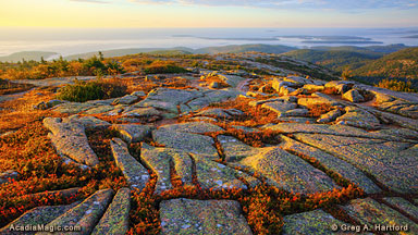
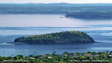
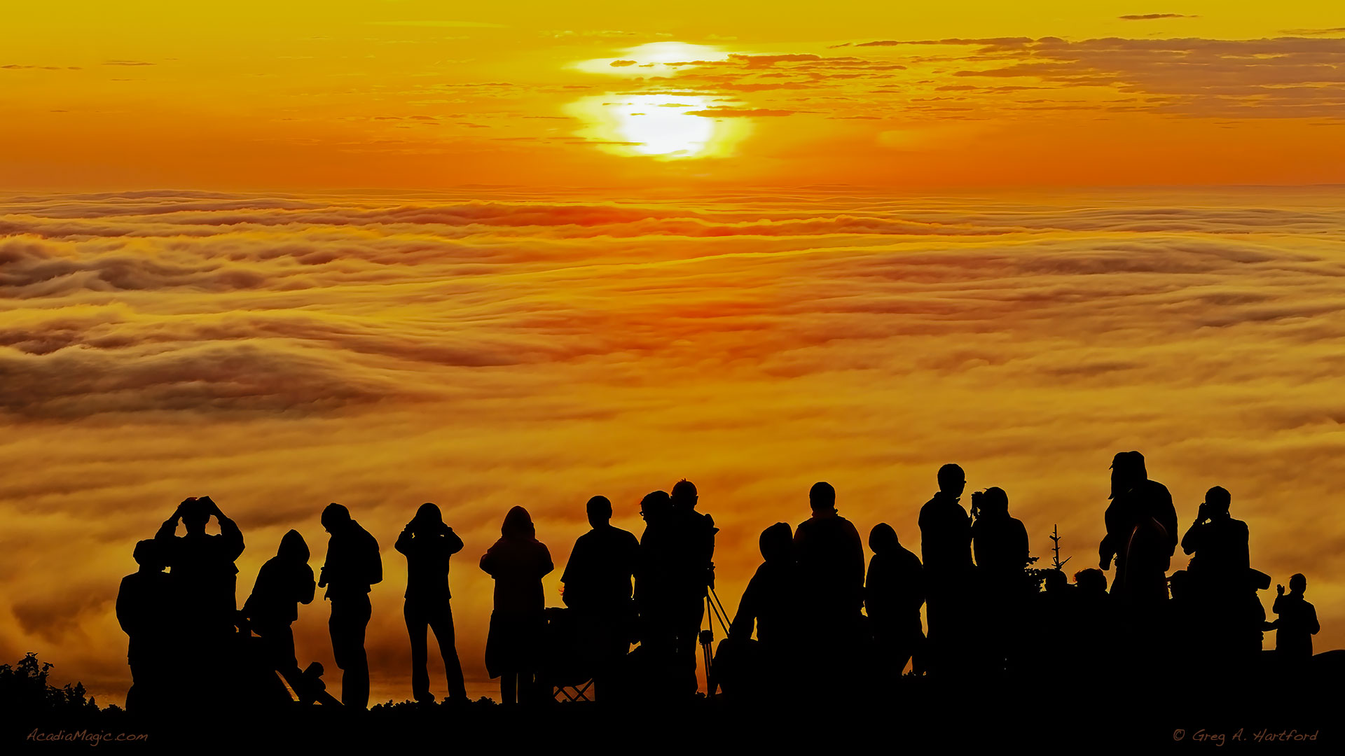
Cadillac Mountain in Acadia National Park, at 1,530 feet (466 meters), is the highest point along the North Atlantic seaboard and the first place to view sunrise in the United States from October 7 through March 6. It is one of over 20 mountains on Mount Desert Island (MDI), Maine that were pushed up by earth's tectonic and volcanic forces millions of years ago. Were it not for the once enormous glaciers that sheared off their tops, they would be even higher than what we see today. You can easily see the results of this on a smaller scale by viewing the slopes on the Porcupine Islands in the distance. The North side is on the left and the steeper slope, or the downside, is on the right east side. The glaciers crept across the land here from the left to the right (in a southerly direction) and stretched out to sea as far as 400 miles (644 kilometers)!

Coastal Location

Cadillac Mountain is in Bar Harbor, Maine, a popular coastal resort known for its unique blend of a Down East fishing village with quiet community charm. The town's shopping district can easily be seen from the eastern side of the mountain and is particularly striking to view when there is a large cruise ship in the harbor. Cadillac Mountain is by far the most dominant land feature on MDI and for many miles along the Maine coast. As one would expect, most activities and businesses revolve around the ocean and the park itself. During normal season, there is a free shuttle bus service available that connects most important points on Mount Desert Island as well as to a few on the mainland.

The Summit Road

The Summit Road officially opened in 1931. It meanders along the north and western side of the mountain for approximately 3.5 miles (5.6 km) until reaching the top. There are several observation points that offer prime viewing opportunities. Take advantage of them on the way up as well as on the way back down. It is easy to get caught up in the views while driving but remain attentive as the road is often beside steep cliffs. Exercise caution when getting in and out of your vehicle as this is a well-traveled road during the summer and autumn months. Note: Vehicle reservations are required for the Cadillac Summit Road from May 24 through October 22, 2023.

Panoramic Views

To the East, one greets the sunrise over Schoodic Peninsula on the mainland. There are several islands off the coast such as Sheep Porcupine and Bald Porcupine. To the Northeast is the business district of Bar Harbor. To the North is Trenton. To the South is Islesford. To the Southwest is Southwest Harbor which is particularly beautiful in the late evening as the lights come on. To the West is Eagle Lake, Blue Hill Mountain and, of course, the setting sun. And all around you is pink granite with forests of spruce and pitch pine combined with tiny subalpine plants (such as cinquefoil), squat, gnarled trees, wild blueberries, and various sized boulders. What is there not to love here?

The Geological Forces

Take note of the deep gouges in the granite on Cadillac Mountain that often follow a north south direction. Millions of years of climate change with several enormous continental glaciers squashed the land and sheared off mountaintops. The last glacier retreated about 18,000 years ago, was over 1 mile high, and reached as far as 400 miles out to sea. It was so powerful that it shifted the orientation of the mountains from east-west to north-south. 360 - 380 million years ago, during a time referred to as the Devonian Period, volcanic forces were at play. The magma chamber of a volcano collapsed. What is now seen as the summit of Cadillac Mountain is one edge of the collapsed volcano.

The Evidence Remains

Geological evidence is all around us. A Mount Desert Island map shows the elongated lakes, ponds, and Somes Sound. Now look at the out islands such as Sheep Porcupine. One side has a gentle slope. The other side is steep with many deposits (referred to as a “Drumlin”). The land is like a book. One must learn the language in order to read it. Talk with a Park Ranger about the geographical forces that shaped Cadillac Mountain and the rest of the island. Schoodic Peninsula is especially interesting for the volcanic magma intrusions along the coast. The narrow darker sections of rock that run from the higher levels toward the ocean with lighter granite on either side are the volcanic intrusions.

Early Inhabitants

Abnaki Indians referred to Mount Desert Island as “Pemetic” (sloping land). New evidence suggests that their villages were on the island but they journeyed to the mainland during warmer months seeking resources such as returning salmon. On September of 1604 AD, the smoke from their campfire caught the attention of the famous French explorer Samuel de Champlain, who then decided to move in for a closer look. Unfortunately, the high tide concealed a rock formation called the “Spindle.” After striking it and damaging the ship's hull, Champlain was forced to seek protection in Otter Cove for months of repairs. He named the island “Isles des Monts Desert” for the bare-rock summits of the granite mountains.

General History - Name

Cadillac Mountain was named after the French explorer and adventurer, Antoine Laumet de La Mothe, Sieur de Cadillac in 1918. Prior to this, it was known as Green Mountain. From about 1534 through 1763, a substantial part of the North American continent was colonized and under the control of France. During this time, it was known as “New France” and at its peak in 1712, extended all the way from Newfoundland to the Rocky Mountains and the Gulf of Mexico. In 1688, Antoine Laumet de La Mothe Sieur de Cadillac was given ownership of over 100,000 acres of land along the present-day Maine coast which included Mount Desert Island and areas next to present-day Union River.

Green Mountain Cog Railway

Starting in 1883, there was a slow cog railway excursion to the summit called the Green Mountain Cog Railway. Starting at Eagle Lake on the western side of the mountain, it made the 1.1 mile (1.77 km) climb to the summit where the Green Mountain House Hotel was awaiting the arrival of visitors and overnight guests. There were two steam locomotives. The primary one was called “Mount Desert.” The second had no special name other than being referred to as locomotive “number 2.” Unfortunately, the seasonal railway had a relatively short run, and operations were terminated in 1890. The equipment was then sold and shipped to Mount Washington Cog Railway of New Hampshire.

Gift Shop, Facilities, Parking

There is a small gift, snack, and information center with bathroom facilities called the Cadillac Summit Center at the top next to the eastern observation area. You will find it on the right just as you reach the summit. A large parking area is to the left. Even so, there are some sunrises during peak season when the parking area is completely full, so vehicles are parked for some distance on the sides of the summit roadway. Before arriving at the summit, there is also a western observation area with its own parking. During sunsets, this parking area can quickly get filled. In either parking areas, it is best to arrive early to be sure to get a parking spot. There are a variety of walking paths close by.

Some Interesting Stats & Facts

  • Accessibility: A short trail is wheelchair accessible for views of Frenchman Bay and the Porcupine Islands. The seasonal Summit Center has a wheelchair accessible entrance, parking, and restrooms.
  • The elevation is 1,530 feet (466.34m)
  • Summit Road Entrance GPS: Latitude 44.368891; Longitude -68.238506
  • Cadillac Mountain used to be called Green Mountain.
  • In the late 1800's there was a hotel on the summit called Green Mountain House Hotel.
  • Cadillac Mountain was named after the Frenchman, Antoine Laumet de La Mothe, Sieur de Cadillac.
  • Huge continental glaciers sheared off the tops of the mountains.
  • The last glacial period impacting this area ended about 18,000 years ago.
  • The published coordinates for the U.S. Coast and Geodetic Survey benchmark are as follows:
    • 44 degrees 21 minutes 04.53 seconds North (44 21 04.53 N)
    • 68 degrees 13 minutes 37.542 seconds West (68 13 37.542 W)
    • North American Datum of 1927 (NAD-27)
    • 460 meters above sea level

Two Special Places

Greg A. Hartford, photographer, author, publisherThere are two special places that seem to feed our souls like nothing else can. One is the open sea. This has a unique calling that may span millions, or perhaps billions of years, and is something that is etched into the memory of our collective DNA, calling us as if to return home. It draws us towards it at every sound and motion of an incoming wave. The other is the view we experience from high on top of a mountain. It is as if we are raised up to where we can see much further than ever before. The experience must be similar to the first time when our fathers or mothers lifted us up and placed us on their shoulders. It was thrilling, perhaps a bit terrifying at the same time. Will we fall? What can we see and learn from this newfound height that we had not learned before from whence we came? On Cadillac Mountain, on the amazing coast of Maine on Mount Desert Island, we get to experience both amazing experiences in one place, at one time, in one unique and exceptional moment. We are both drawn closer and lifted higher to a place where our minds and hearts join with each drawn breath, and each pause of silence. We must be still and empty ourselves of all but this.

Return to Top