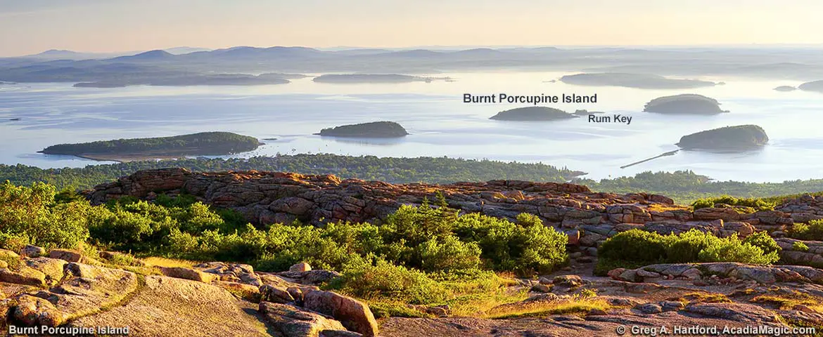
Burnt Porcupine Island & Rum Key
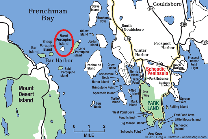
Burnt Porcupine Island is one of the five Porcupine Islands located in Frenchman Bay of Hancock County immediately east of Bar Harbor and the much larger Mount Desert Island. The island archipelago includes Bar Island (on the far left) and is part of Gouldsboro, Maine, even though the islands are so close to Bar Harbor and so far away from the town center of Gouldsboro which is on the mainland next to Schoodic Peninsula. Burnt Porcupine Island is privately owned and has been in the same family for over one hundred years despite the fact that the National Park Service has expressed a desire to purchase it to protect it from future development. The island is approximately 40 acres in size (includes Rum Key) with an elevation of 108 feet (33 meters). Its GNIC ID number is 563268.
Burnt Porcupine Island GPS: 44.4048015, -68.1780671
Additional Info:
The group of Porcupine Islands includes Bald, Burnt, Long, Sheep, and the much smaller Rum Key. All, except Burnt Porcupine Island, are part of Acadia National Park. Because Bar Island is so close to these islands, some people often conceptually think of them as being part of the same group ing. When you view the islands on a map like the one here, Park land is often colored green. Burnt Porcupine Island is the one that has remained white, separate from the rest making it easy to spot. Like the other islands in the group, Burnt Porcupine has an identifiable shape that is common with glacial impacted islands. They have a gentle slope on one side and a steep slope on the other side (called a “drumlin”). This was caused by the movement of the glaciers over many thousands of years.
Resources
- Gouldsboro Town Office: (207) 963-5589
Town Manager, 59 Main St., Prospect Harbor, ME 04669 - Gouldsboro Historical Society: Website
- Bar Harbor, Maine
A Mouse & Tail
When viewing Burnt Porcupine Island and Rum Key from the heights of Cadillac Mountain on Mount Desert Island, the two almost look connected like a mouse and its tail flattened out in the middle of several other islands. It appears to have a slightly different silhouette shape when compared to Sheep Porcupine and Bald Porcupine. We certainly take things for granted now-a-days as to how easy it is to get from one location to another. Life gets compressed somehow. Imagine what it was like in the 1600’s when you either sailed, rowed, or walked. If you were lucky when on land, you had a horse. Imagine how long it took to move around and explore places like Cadillac Mountain. There were no roads, lots of brush and trees, and perhaps a walking path created by Native Americans.